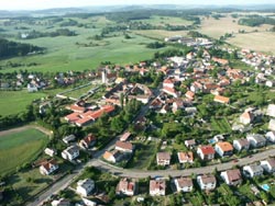
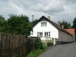
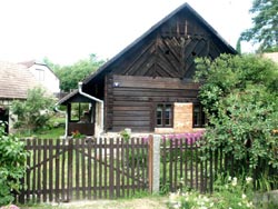
 Kovářov – stage
1
Kovářov – stage
1
(N49°31.074' E14°16.702')
Dear visitors, welcome to the South Bohemian village Kovářov, where you can find three routes of the Instructional Trail with twenty-one stops showing this area.
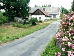
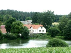
Kovářovsko (Kovářov Region) offers pleasant and varied countryside with a lot of hills, woods, and a number of ponds with a variety of plants and animals.
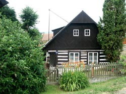
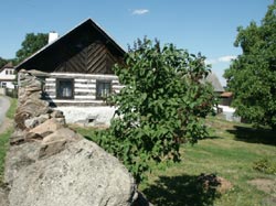
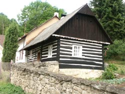
This area is unique from a geological point of view due to interesting rock formations or boulders in various shapes. The folk architecture is interesting as well.
You can see valuable historical buildings in villages here. Kovářovsko is also an important ethnographical centre. It belongs to the area called Kozácko
(Táborsko - Milevsko). Folk songs and dances, and theatre performances traditionally have been here and you can see them at the stops.
The history
of the village reaches back to the 13th century. The first written mention is from 1220, when a country gentleman Budilov from Kovářov lived in the fortified
settlement here. From 1461 Kovářov belonged to Jan from Rožmberk and then to the king as well. The Švamberks are the most known from the following owners.
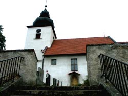
From the end of the 16th century it belonged to the Orlík estate. The Gothic All Saints' Church is the oldest place of interest in Kovářov. It has been a parish
church since 1220. The biggest development of the village we can find in the 17th and 18th centuries and most of the historical monuments are from that time.
The sculptural group Calvary and the sculpture of St. Jan Nepomucene, both from the sculptor Brokoff's workshop, are among the most important. The building
of the old Baroque rectory from 1739 is interesting because of the attic roof typical for buildings of this kind in the Orlík estate.
Kovářov consists of seventeen
settlements with 1,500 inhabitants and its area is 5050 ha.
 Březí – stage
2 (the gray circuit)
Březí – stage
2 (the gray circuit)
The first mention of the village is from the 15th century. At that time
Jindřich from Březí lived in the fortified settlement here. He belonged
to the families of country gentlemen the Břízskýs and the Netvorskýs
from Břízí. The village Vepice, not far away, belonged to the fortified
settlement as well. Jan Šturm from Hyršfeld became an owner of Březí
at the end of the 16th century and he annexed it to Kovářov. Then the settlement was abandoned and in the 18th century it was destroyed.
To the north, near the road to Předborice, you can find the Calvary, reminding visitors of a battle from the Thirty Years' War.
 Dobrá Voda –
stage 3 (the gray circuit)
Dobrá Voda –
stage 3 (the gray circuit)
This used to be a farmstead which belonged to the Petrovice manor. The
name means Good Water, named for the well with healing water which lay
in the Horychová wood. Later a village arose here. It had three manors and
three cottages. Only a few buildings have been preserved. In the village you
can find a small stone belltower from 1895 and near it a small chapel of
the Virgin Mary.
 Hostín – stage
4 (the gray circuit)
Hostín – stage
4 (the gray circuit)
Originally it was a Middle-Aged settlement, first mentioned in the 13th
century. A few wooden framed houses have been preserved. The settlement
belonged to the Švamberks, later to the Čechovskýs from Čechovice
and during the Thirty Years' War it was nearly destroyed. There is a small
chapel from 1908 in the village. Professor Čenek Holas, a well-known
collector of national songs and dances, spent his youth here. On the northern outskirts there is a small monument to the pilot Václav Pešička,
who was born here and died at the end of World War II in Poland.
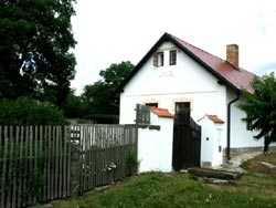
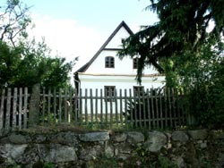
 Chrást – stage
5
Chrást – stage
5
V obci se dochovalo několik roubených chalup ve stylu
venkovské lidové architektury. Uprostřed vsi stojí kaplička
z počátku 20. století zasvěcená Panně Marii. Dějiny této
osady jsou spjaty s nedalekými Holešicemi, kde se dochovala
tvrz sloužící v současnosti k rekreaci. Na kraji vsi stojí
bývalá budova školy, která je dnes využívána k
turistickým účelům. Jižně od osady byla známá
schwarzenbergská obora, v níž žili jeleni, daňci a mufloni.
Obora byla sice po 2. světové válce zrušena, ale daňci se
zde udrželi dodnes.
 Kotýřina – stage
6
Kotýřina – stage
6
(N49°30.415' E14°15.332')
(the yellow circuit)
The old time village with the fortified settlement is first mentioned in 1291.
Originally it belonged to the judge Budil and then several families owned the
village. In 1519 Jan Hodějovský from Hodějov became a farm manager here.
He supported writers and poets and they often met here. The farm building
Nr.1 stands in the place of the former fortified settlement. The memorial
tablet to this Czech humanist has been on the front wall since 1938.
The history of the village has been connected with the history of Kovářov since 1584 when Kotýřina was sold to the Švamberks and became
a part of the Orlík estate.
 Lašovice – stage
7
Lašovice – stage
7
Ves se připomíná již v roce 1230, v roce 1370 zde bylo pět
vladyckých dvorů. O Lašovicích jako farní osadě jsou zmínky
až z doby arcibiskupa Arnošta z Pardubic. V 15. století
vznikla z lašovického dvora tvrz se statkem, který držel v
roce 1531 Bohuslav z Lašovic. V roce 1604 byla tvrz se dvorem i
vsí prodána Švamberkům a od té doby patřila k orlickému
panství. Mezi nejvýznamnější památky patří raně gotický
kostel Navštívení Panny Marie z let 1260 – 1270, který je
od roku 1365 uváděn jako kostel farní. Nad Lašovicemi byla v
roce 1940 postavena turistická chata nazvaná podle tamních
samot Onen Svět. Vedle ní je nově vystavěná Langova
rozhledna, ze které jsou krásné výhledy na Brdy, Šumavské
podhůří a Šumavu.
GCPPP5 Onen svet
by lucky&spol
 Předbořice –
stage 8
Předbořice –
stage 8
První zmínky o vsi pocházejí z roku 1219. Bývala zde tvrz
patřící Předborovi z Radešína. Jméno má buď po tomto
Předborovi nebo podle své polohy před borem pokrývajícím
vrch Hrby. Vladykové z Předbořic používali erbu „kotouč a
klenot půl panny prostovlasé o dvou barvách“. Od roku 1504
patřily Předbořice k orlickému panství. V 17. století zde
vzniklo mnoho roubených chalup, jedna z nejzachovalejších je
na návsi vedle kostela. Raně gotický kostel sv. Filipa a
Jakuba pochází z konce 13. století, jako farní je připomínán
v roce 1365. Z Předbořic pocházel Karel Cvrk, ředitel školy,
překladatel cestopisů, autor četných povídek. Zasloužil se
o zasazení pamětní desky Janu Hodějovskému z Hodějova v Kotýřině.
 Radvánov – stage
9
Radvánov – stage
9
(N49°31.890' E14°15.430')
(the yellow circuit)
The history of Radvánov comes back to the beginning of the 15th century.
In 1404 it belonged to the Břevnov monastery and 130 years later it was
sold to the sons of Kryštof from Švamberk by the Břevnov abbot Jakub.
At that time the village became a part of the Orlík estate. The small chapel
was built in 1913 and near it you can find a granite cross with Jesus Christ from 1900. In the surroundings of Radvánov there are a lot of
granite rock formations, for example a logan-stone near Betlem, about 1 km to the southwest of the village.
 Řenkov – stage
10 (the gray circuit)
Řenkov – stage
10 (the gray circuit)
The settlement is first mentioned in the 15th century. It lies in a beautiful
valley to the northwest of the ridge Višták on the right tributary of Předbo-
řický brook. Mašek and Hlavín Petr from Řenkov lived here in 1497. From
1575 the village belonged to Kryštof from Švamberk and later to the
Schwarzenbergs. The ruins of the stone fortified system can be seen
around the village. Several framed houses come from 17th and 18th centuries. On the slopes of the hill Višťák you can see a lot of boulders
typical for this countryside.
 Vepice – stage
11 (the gray circuit)
Vepice – stage
11 (the gray circuit)
The original name of this village was Epice for the old Czech name Epp.
A family of country gentlemen who had a coat-of-arms with a head of a dog
lived in the fortified settlement here. The first mention of the village is from
1373, when a country gentleman Jaroslav from Vepice lived here. František
from Vepice is well-known because he was an abbot in the monastery in
Milevsko and he rebuilt the church of St. Giles in Milevsko. On the front wall
here you can find the coat-of-arms with the dog's head. The fortified settlement Vepice used to stand on a small island in Nový pond in the
southeast. But only the island has been preserved. Near the Novy pond there is now a stone-pit with high-quality decorative granite.
 Vesec – stage 12
(N49°30.788' E14°15.521')
(the yellow circuit)
The first mention of the village comes from 1223. In 1260 Vesec belonged to
Ratibor from Vesec. Until the second half of the 15th century there used to
stand a fortified settlement of country gentlemen from Vesec. At that time
Vesec became a part of the Kovářov estate. Then the fortified settlement was
abandoned and later was destroyed. In 1616 it became a part of the the Orlík
estate again. The chapel is from 1883. The settlement Slavoňov lies to the northwest from Vesec. In the past there used to be a mansion from
the second half of the 16th century, which was later destroyed, and also a brewery, a distillery, and a Baroque granary. The dominant feature
of Slavoňov is a high brick smokestack of the former brewery and distillery. On the top you can see a nest of storks.
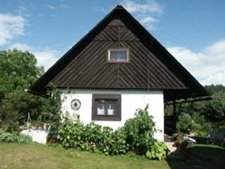
 Vladyčín –
stage 13 (the gray circuit)
Vladyčín –
stage 13 (the gray circuit)
The first mention is from the 14th century when the village belonged to the
monastery in Milevsko. After 1584 it became a part of the Orlík estate.
Vladyčín is well-known due to several wooden framed houses around the
house Nr. 5. These buildings form an irregular four-winged house and
also the framed granary is valuable. In the square you can see an interesting belfry made from the trunk of a tree.The small chapel of the Virgin
Mary lies near the road to Petrovice. The wooded mountain ridge called Vladyčínská Hůrka extends between Vladyčín and Dobrá Voda.
 Zahořany – stage
14
Zahořany – stage
14
Bývalé středověké městečko se připomíná v roce 1323 v
listině Jana Lucemburského a patřilo Zvíkovu. V roce 1575
koupil městečko společně se Zvíkovem Kryštof ze Švamberka,
po roce 1608 připadlo panství orlickému. Za třicetileté
války bylo městečko téměř úplně zničeno a řada obyvatel
zahynula i na následky moru. Koncem 18. a počátkem 19.
století vznikala na troskách bývalého městečka nová
vesnice. Na západní straně vsi se zvedá hřbet zvaný Babiny,
na jehož vrcholu stojí sloupová boží muka. Byla postavena v
první polovině 19. století jako památka obětem moru a
třicetileté války. V Zahořanech se narodil Čeněk Holas, významný
sběratel lidových písní a tanců.
 Záluží – stage
15
Záluží – stage
15
Osada, která byla tvořena v minulosti z poplužních dvorů, se
nachází nad Zálužským rybníkem, který patří do velké
skupiny rybníků nacházejících se na Kovářovsku. Tyto vodní
plochy vznikaly většinou již ve středověku na místech původních
mokřin a bažin umělým zásahem člověka, ale záhy se začlenily
do okolní krajiny. Na okrajích rybníků našly své uplatnění
původní druhy rostlin, především ze společenstva rákosin a
vysokých ostřic. Patří mezi ně orobinec širokolistý,
chrastice rákosovitá, kosatec žlutý a další druhy. Také
okolí Kovářova se svým členitým a zvlněným povrchem je z
hlediska flóry druhově zajímavé, pestré a obsahuje řadu
druhů význačných pro tuto oblast. Zajímavou lokalitou je Koňský
vrch, kde se můžeme setkat s druhy jako je vítot chocholatý,
řepík lékařský, pamětník rolní a další.
 Zlučín – stage
16
Zlučín – stage
16
stage v obci Zlučín přináší informace o Kovářovsku,
které je významné z hlediska národopisu. Tato oblast se řadí
etnograficky ke Kozácku, které zahrnuje Táborsko a Milevsko.
Jedno vysvětlení názvu oblasti nacházíme v úpravě
čepečku žen, jehož tvrdě naškrobená holubička trčela zvláště
pod uvázaným bílým šátkem „jako kozí růžky“. Kozácký
kroj vyniká pracnou bílou výšivkou, z níž dokázaly ženy
tvořit něžné vzory na bílém plátně. Na Kovářovsku se též
narodily osobnosti kulturního a společenského života,
profesoři Čeněk Holas a Čeněk Zíbrt. Tito autoři,
sběratelé mnoha lidových písní, tanců, zvyků, významně
přispěli k zachycení a uchování národní kultury. Ve
sbírkách těchto autorů nacházejí náměty i kovářovské
folklorní soubory, které společně s krojem udržují zdejší
lidovou kulturu.
 Žebrákov –
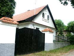
stage 17
Žebrákov –
stage 17
Ves patřila k majetku orlickému a dochovalo se zde několik
roubených chalup. Snad nejzajímavější je polozděná a
poloroubená chalupa z roku 1779 čp. 2. Vsí protéká Žebrákovský
potok, který se vine malebným údolím a ústí do nejdelší
zátoky orlické přehradní nádrže, 2,1 km dlouhé. Památkou
spíše technického rázu jsou pozůstatky cihelny při Žebrákovském
potoce na jihovýchodním okraji vsi. Cihelny zde bývaly tři:
Laňkova, Rozhoňova a Kuchtova. Ignác Kuchta byl potomkem
vladyků z Květuše a Humňan, byl i spoluzakladatelem lihovaru
ve Slavoňově. Rázovitou figurkou Žebrákova byl v první
polovině 20. století František Kuchta, přezdívaný žebrákovský
Cimbura nebo také strejc Franc. Říká se, že dovedl
nadzvednout nápravu plně naloženého žebřiňáku.
 Kovářovská hůrka –
stage 18 (the gray circuit)
Kovářovská hůrka –
stage 18 (the gray circuit)
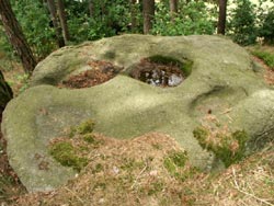
This wooded hill lies northwest of Kovářov, 535 metres a.s.l. It is formed
from granite and here you can find interesting boulders with rock bowls.
On the southeastern slope there is a Jewish cemetery where the Jews from
Kovarov and surrounding areas were buried. Kovarovska Hurka was often
visited by brigades of firemen in Kovarov and by students' organizations
in past. In 1947 the construction of a sports ground started here. Finances
were provided by the Union of the Czech Youth, by some companies,
and especially by the association of Kovarov's natives in Prague. The sports ground was opened on 22nd May 1949.
GC2WB72 Misky na Kov. h. (ITK 18)
by A. da Mek
GC2WB7C 3 misky na Kov. h.
by A. da Mek
 Skalní brána –
stage 19
Skalní brána –
stage 19
(N49°30.524' E14°15.565')
(the yellow circuit)
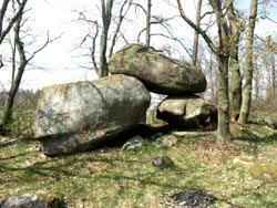
This interesting natural feature was formed by the erosion of granite massifs.
It is a counterfeit rock gate, two big boulders form pillars and the third one
lies on the top of them. This reminds viewers of a gate. The way between
the boulders is nearly four metres long and one metre wide. The height
is 1.5 - 1.8 metre. The rock gates were usually formed in big rock formations
by the work of water and wind erosion in tender rock. A part of the rock wall
was broken up and then removed by water and wind. A big window reminding
of a gate appears in this place.
GC14YP6 Rock gate (ITK 19)
by A. da Mek
 Sfinga – stage
20
Sfinga – stage
20
(N49°31.183' E14°14.491')
(the yellow circuit)
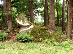
This granite boulder is in the shape of Sphinx, a silent guard of Egyptian
pyramids. It was formed by wind erosion. The Kovářov area is formed
by amphibolicbiotic porphyritic granite, the rock belongs to the so called
Central Bohemian Pluton and comes from the Palaeozoic Age. In some areas
you can find porphyry, aplite, granite, and silica, mostly in higher locations.
In many places you can see lone boulders and also groups of big granite
boulders which look like seas of stones. The wind erosion can be seen on many of them. A lot of boulders have rock bowls on the surface.
 Radava – stage
21
Radava – stage
21
Vážení návštěvníci, zavítali jste do kempu Radava, který
nese název vesnice, jež ustoupila vodní nádrži Orlík. Tato
oblast patří ke Kovářovsku, které Vám nabízí tři trasy
Naučné stezky s dvaceti jedna stagemi. Stezka je
pozvánkou a doporučením, jak poznat zdejší okolí s příjemnou
členitou krajinou se spoustou pahorků, lesních porostů, velkým
množstvím rybníků i malých rybníčků, které významně
ovlivňují druhovou pestrost rostlin a živočichů.
Zdejší oblast je výjimečná z hlediska geologického a umožňuje
zhlédnout pozoruhodné skalní útvary či balvany rozmanitých
tvarů. Neméně zajímavá je i lidová architektura, která
ukazuje v jednotlivých osadách historicky cenné stavby. Velký
význam má Kovářovsko z hlediska národopisu, patří do
oblasti Kozácka (Táborska – Milevska), může se pochlubit též
osobnostmi z oblasti sběratelské a dlouholetou divadelní či
folklorní tradicí, se kterou se budete setkávat na
jednotlivých stagech.
Historie vsi sahá do začátku 13. století. První písemná
zmínka pochází z roku 1220, kdy na zdejší tvrzi sídlil
vladyka Budilov z Kovářova. Od roku 1461 patřil Kovářov Janu
z Rožmberka, krátce byl i majetkem krále. Z dalších majitelů
jsou nejznámější Švamberkové a od konce 16. století patřil
k orlickému panství. Nejstarší památkou v Kovářově je
gotický kostel Všech svatých, farním byl již v roce 1220.
Rozkvět zaznamenala ves v 17. a 18. století a z této doby
pochází většina kulturních památek. Mezi nejvýznamnější
patří sousoší Kalvárie a socha sv. Jana Nepomuckého z
dílny sochaře Brokoffa. Architektonicky zajímavou je budova
staré barokní fary z roku 1739 s mansardovou střechou,
typickou pro stavby tohoto druhu na orlickém panství.
Kovářov se jako správní jednotka skládá ze sedmnácti osad
s patnácti sty obyvateli a rozkládá se na ploše 5050
hektarů.
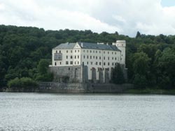
GCV250 Orlik - zamek
by Malahavranice Team