 Kovářov – stage
1
Kovářov – stage
1
(N49°31.074' E14°16.702')
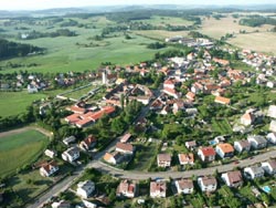
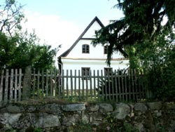
Dear visitors, welcome to the South Bohemian village Kovářov, where you can find three routes of the Instructional Trail with twenty-one stops showing this area.
Kovářovsko (Kovářov Region) offers pleasant and varied countryside with a lot of hills, woods, and a number of ponds with a variety of plants and animals.
This area is unique from a geological point of view due to interesting rock formations or boulders in various shapes. The folk architecture is interesting as well.
You can see valuable historical buildings in villages here. Kovářovsko is also an important ethnographical centre. It belongs to the area called Kozácko
(Táborsko - Milevsko). Folk songs and dances, and theatre performances traditionally have been here and you can see them at the stops.
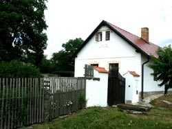
The history
of the village reaches back to the 13th century. The first written mention is from 1220, when a country gentleman Budilov from Kovářov lived in the fortified
settlement here. From 1461 Kovářov belonged to Jan from Rožmberk and then to the king as well. The Švamberks are the most known from the following owners.
From the end of the 16th century it belonged to the Orlík estate. The Gothic All Saints' Church is the oldest place of interest in Kovářov. It has been a parish
church since 1220. The biggest development of the village we can find in the 17th and 18th centuries and most of the historical monuments are from that time.
The sculptural group Calvary and the sculpture of St. Jan Nepomucene, both from the sculptor Brokoff's workshop, are among the most important. The building
of the old Baroque rectory from 1739 is interesting because of the attic roof typical for buildings of this kind in the Orlík estate.
Kovářov consists of seventeen
settlements with 1,500 inhabitants and its area is 5050 ha.
 Vepice – stage
11
Vepice – stage
11
The original name of this village was Epice for the old Czech name Epp.
A family of country gentlemen who had a coat-of-arms with a head of a dog
lived in the fortified settlement here. The first mention of the village is from
1373, when a country gentleman Jaroslav from Vepice lived here. František
from Vepice is well-known because he was an abbot in the monastery in
Milevsko and he rebuilt the church of St. Giles in Milevsko. On the front wall
here you can find the coat-of-arms with the dog's head. The fortified settlement Vepice used to stand on a small island in Nový pond in the
southeast. But only the island has been preserved. Near the Novy pond there is now a stone-pit with high-quality decorative granite.
 Dobrá Voda –
stage 3
Dobrá Voda –
stage 3
This used to be a farmstead which belonged to the Petrovice manor. The
name means Good Water, named for the well with healing water which lay
in the Horychová wood. Later a village arose here. It had three manors and
three cottages. Only a few buildings have been preserved. In the village you
can find a small stone belltower from 1895 and near it a small chapel of
the Virgin Mary.
 Vladyčín –
stage 13
Vladyčín –
stage 13
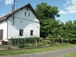
The first mention is from the 14th century when the village belonged to the
monastery in Milevsko. After 1584 it became a part of the Orlík estate.
Vladyčín is well-known due to several wooden framed houses around the
house Nr. 5. These buildings form an irregular four-winged house and
also the framed granary is valuable. In the square you can see an interesting belfry made from the trunk of a tree.The small chapel of the Virgin
Mary lies near the road to Petrovice. The wooded mountain ridge called Vladyčínská Hůrka extends between Vladyčín and Dobrá Voda.
 Řenkov – stage
10
Řenkov – stage
10
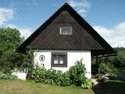
The settlement is first mentioned in the 15th century. It lies in a beautiful
valley to the northwest of the ridge Višták on the right tributary of Předbo-
řický brook. Mašek and Hlavín Petr from Řenkov lived here in 1497. From
1575 the village belonged to Kryštof from Švamberk and later to the
Schwarzenbergs. The ruins of the stone fortified system can be seen
around the village. Several framed houses come from 17th and 18th centuries. On the slopes of the hill Višťák you can see a lot of boulders
typical for this countryside.
 Březí – stage
2
Březí – stage
2
The first mention of the village is from the 15th century. At that time
Jindřich from Březí lived in the fortified settlement here. He belonged
to the families of country gentlemen the Břízskýs and the Netvorskýs
from Břízí. The village Vepice, not far away, belonged to the fortified
settlement as well. Jan Šturm from Hyršfeld became an owner of Březí
at the end of the 16th century and he annexed it to Kovářov. Then the settlement was abandoned and in the 18th century it was destroyed.
To the north, near the road to Předborice, you can find the Calvary, reminding visitors of a battle from the Thirty Years' War.
 Hostín – stage
4
Hostín – stage
4
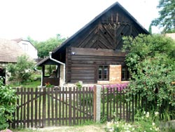
Originally it was a Middle-Aged settlement, first mentioned in the 13th
century. A few wooden framed houses have been preserved. The settlement
belonged to the Švamberks, later to the Čechovskýs from Čechovice
and during the Thirty Years' War it was nearly destroyed. There is a small
chapel from 1908 in the village. Professor Čenek Holas, a well-known
collector of national songs and dances, spent his youth here. On the northern outskirts there is a small monument to the pilot Václav Pešička,
who was born here and died at the end of World War II in Poland.
 Kovářovská hůrka –
stage 18
Kovářovská hůrka –
stage 18
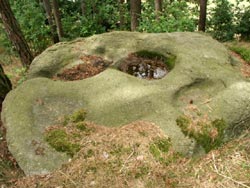
This wooded hill lies northwest of Kovářov, 535 metres a.s.l. It is formed
from granite and here you can find interesting boulders with rock bowls.
On the southeastern slope there is a Jewish cemetery where the Jews from
Kovarov and surrounding areas were buried. Kovarovska Hurka was often
visited by brigades of firemen in Kovarov and by students' organizations
in past. In 1947 the construction of a sports ground started here. Finances
were provided by the Union of the Czech Youth, by some companies,
and especially by the association of Kovarov's natives in Prague. The sports ground was opened on 22nd May 1949.
GC2WB72 Misky na Kov. h. (ITK 18)
by A. da Mek
GC2WB7C 3 misky na Kov. h.
by A. da Mek