(Česky: Žlutý okruh)
 Kovářov – stage
1
Kovářov – stage
1
(N49°31.074' E14°16.702')
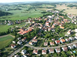
Dear visitors, welcome to the South Bohemian village Kovářov, where you can find three routes of the Instructional Trail with twenty-one stops showing this area.
Kovářovsko (Kovářov Region) offers pleasant and varied countryside with a lot of hills, woods, and a number of ponds with a variety of plants and animals.
This area is unique from a geological point of view due to interesting rock formations or boulders in various shapes. The folk architecture is interesting as well.
You can see valuable historical buildings in villages here. Kovářovsko is also an important ethnographical centre. It belongs to the area called Kozácko
(Táborsko - Milevsko). Folk songs and dances, and theatre performances traditionally have been here and you can see them at the stops.
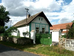
The history
of the village reaches back to the 13th century. The first written mention is from 1220, when a country gentleman Budilov from Kovářov lived in the fortified
settlement here. From 1461 Kovářov belonged to Jan from Rožmberk and then to the king as well. The Švamberks are the most known from the following owners.
From the end of the 16th century it belonged to the Orlík estate. The Gothic All Saints' Church is the oldest place of interest in Kovářov. It has been a parish
church since 1220. The biggest development of the village we can find in the 17th and 18th centuries and most of the historical monuments are from that time.
The sculptural group Calvary and the sculpture of St. Jan Nepomucene, both from the sculptor Brokoff's workshop, are among the most important. The building
of the old Baroque rectory from 1739 is interesting because of the attic roof typical for buildings of this kind in the Orlík estate.
Kovářov consists of seventeen
settlements with 1,500 inhabitants and its area is 5050 ha.
 Radvánov – stage
9
Radvánov – stage
9
(N49°31.890' E14°15.430')
The history of Radvánov comes back to the beginning of the 15th century.
In 1404 it belonged to the Břevnov monastery and 130 years later it was
sold to the sons of Kryštof from Švamberk by the Břevnov abbot Jakub.
At that time the village became a part of the Orlík estate. The small chapel
was built in 1913 and near it you can find a granite cross with Jesus Christ from 1900. In the surroundings of Radvánov there are a lot of
granite rock formations, for example a logan-stone near Betlem, about 1 km to the southwest of the village.
 Sfinga – stage
20
Sfinga – stage
20
(N49°31.183' E14°14.491')
This granite boulder is in the shape of Sphinx, a silent guard of Egyptian
pyramids. It was formed by wind erosion. The Kovářov area is formed
by amphibolicbiotic porphyritic granite, the rock belongs to the so called
Central Bohemian Pluton and comes from the Palaeozoic Age. In some areas
you can find porphyry, aplite, granite, and silica, mostly in higher locations.
In many places you can see lone boulders and also groups of big granite
boulders which look like seas of stones. The wind erosion can be seen on many of them. A lot of boulders have rock bowls on the surface.
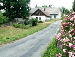
 Vesec – stage 12
(N49°30.788' E14°15.521')
The first mention of the village comes from 1223. In 1260 Vesec belonged to
Ratibor from Vesec. Until the second half of the 15th century there used to
stand a fortified settlement of country gentlemen from Vesec. At that time
Vesec became a part of the Kovářov estate. Then the fortified settlement was
abandoned and later was destroyed. In 1616 it became a part of the the Orlík
estate again. The chapel is from 1883. The settlement Slavoňov lies to the northwest from Vesec. In the past there used to be a mansion from
the second half of the 16th century, which was later destroyed, and also a brewery, a distillery, and a Baroque granary. The dominant feature
of Slavoňov is a high brick smokestack of the former brewery and distillery. On the top you can see a nest of storks.
 Kotýřina – stage
6
Kotýřina – stage
6
(N49°30.415' E14°15.332')
The old time village with the fortified settlement is first mentioned in 1291.
Originally it belonged to the judge Budil and then several families owned the
village. In 1519 Jan Hodějovský from Hodějov became a farm manager here.
He supported writers and poets and they often met here. The farm building
Nr.1 stands in the place of the former fortified settlement. The memorial
tablet to this Czech humanist has been on the front wall since 1938.
The history of the village has been connected with the history of Kovářov since 1584 when Kotýřina was sold to the Švamberks and became
a part of the Orlík estate.
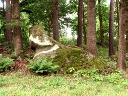
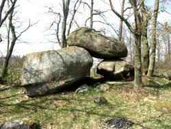 Skalní brána –
stage 19
Skalní brána –
stage 19
(N49°30.524' E14°15.565')
This interesting natural feature was formed by the erosion of granite massifs.
It is a counterfeit rock gate, two big boulders form pillars and the third one
lies on the top of them. This reminds viewers of a gate. The way between
the boulders is nearly four metres long and one metre wide. The height
is 1.5 - 1.8 metre. The rock gates were usually formed in big rock formations
by the work of water and wind erosion in tender rock. A part of the rock wall
was broken up and then removed by water and wind. A big window reminding
of a gate appears in this place.
GC14YP6 Rock gate (ITK 19)
by A. da Mek
photo: Milan Škoch
Source: formerly http://kovarov.cz/ob_stezka.htm,
now http://www.kovarov.cz/detail.php?ID=44